Butler County - A Brief History
As with the page on Lehigh County, it's not my intent to get bogged down with too much detail about this-and-that concerning historical data, but to just offer you a few bits and pieces of the history of Butler County. With that in mind, I offer the following.
All the information herein is paraphrased from the CD entitled: History of Butler County Pennsylvania with Illustrations, by R.C. Brown & Co. in 1895 - 1438 pages - over 70 portraits and maps1. Alas... not a single Klugh is mentioned (at least not in the Index), but it still makes interesting reading.
"Embracing its physical features; aborigines and explorers; public lands and surveys; pioneers; early settlement and subsequent growth; organization and civil admistration; political affairs; the legal and medical proffessions; the press; schools and school laws; internal improvements; agriculture; the temperance cause; military history; the Butler oil and gas fields; sketches of boroughs, townships and villages; religious, educational, social and material progress; biographies and portraits of pioneers and representative citizens, etc., etc."
In 1795 the area of Pennsylvania north and west of the Allegheny River was still a wilderness, inhabited mostly by wild animals and Indians.
At this point in this page, in all honesty I must point out the glaring prejudicial bigotry of the authors concerning the native americans, where they say:
"Before the appearance of the white man... Butler county was a savage-peopled wilderness. The red man... leaving behind no monuments for good... beneath his feet was a fertile soil... his trophies of valor were the scalps of his enemies... his principal amusement [was] the war dance around the burning captive at the stake. He lived, but he lived a useless life, until the time [of] the white man..."Compare this to the author's description of the white settlers:
"These sturdy settlers led simple, wholesome lives. They lived happily and were constantly helpful to one another. The ceaseless round of toil was varied, now and then, by wedding festivities, dances, neighborhood frolics, and other social gatherings calculated... to foster the neighborly spirit so necessary..."Still, the information about the history of the region is of great value when doing genealogical research.
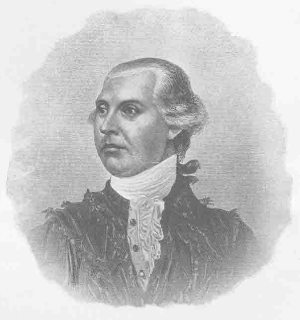
Butler county was named after General Richard Butler (photo below).

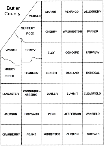
It was erected under authority of an act of the legislature of Pennsylvania and apporved on March 12, 1800. It is bounded by Venango county on the north, Beaver, Lawrence and Mercer counties on the west, Allegheny county on the south, and Armstrong county on the east. Its geographical center is in latitude 40 degs., 45 mins. north, and longitude 2 degs., 47 mins., 30 secs. west of Washington, D.C. Its area is 814 square miles, or 529,960 acres, divided into thirty-three townships, and subdivided into fifty-seven election precincts.

Butler Township was founded in 1804. Clearfield Township was founded in 1804 and derives its name from a cultivated Indian field discovered by pioneers in 1798.
Think of a major street in Butler... anywhere in Butler or wherever you live and consider that it started out as nothing more than a path taken by Indians through the woods.
The Allegheny river was named by the Shawnee Indians and was called "Paliwa-thorika"; by the Delawares as "Alligawi-sipu", or the river of the Allegans.
The Senecas were the occupants of this part of the State, as well as the Delawares, the Shawanese, and Munceys.
The French were the pioneers of Western Pennsylvania (and the Ohio valley) from Canada in 1749.
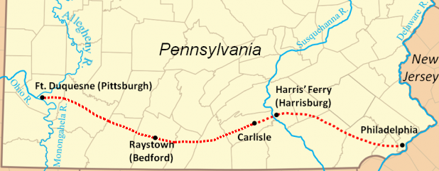
To counter the exploration of the French, and early in 1754 the Governor of Virginia sent a small force to the confluence of the Allegheny and Ohio rivers and erected of a fort - Fort Duquesne. The competition between the French and English eventually escalated into what is known as the French and Indian war. It was this fort that eventually became known as Fort Pitt. A community grew up around it which later became known as Pittsburgh. The red dotted line (see map below) was called Forbes' Road. It was named after General John Forbes and was the route taken to go between Philadelphia and Fort Duquesne (Fort Pitt). The modern route of Forbes' Road is approximately the same as the Pennsylvania Turnpike (I-76). Also, when anyone came to the Susquehanna River they had to cross it on a ferry. In 1733 John Harris Sr. was granted rights to 800 acres of land in the area, set up a ferry at the site, a community grew up around it and it became known as Harrisburg2.

The Indians realized the plans of the white people, tried to hold on to their lands, but to no avail. The first attack made by the colonists on the Indians, was that in Kittanning in 1756 by 307 soldiers under Lieutenant Colonel Armstrong. An Indian town was burned and with it many Indian women and children. Seventeen colonists were killed, thirteen wounded and nineteen missing. The Seneca, near Slippery Rock creek, were friendly, but the Delawares and Shawnees were hostile to the whites.
An example of pioneers trying to make it in the wilderness is the following: "William Barron, of Butler county, farmer, applies for a tract of three hundred acres of land situate[d] on the Glade run, a branch of Slippery rock creek, being what is called commonly, 'The Stripe,'." Further he says that in May of 1797 he erected a cabin sixteen feet square, deadened trees on three acres and cleared two more acres. In addition, Robert Morris became the owner of more than three-quarters of a million acres of land in the western part of Pennsylvania, seventy thousand acres of which laid in what became Butler county. and he held the warrant for the land on which the borough of Butler is built.
The first movement in Butler county for the regulation of liquor took place in 1804. Part of the petition was as follows:
"To the Honorable Jesse Moore... Your petitioners conceive it is in the power of the honorable court to set a stipulated price on the provisions for man and horse, and liquors, in the taverns of said county. As they conceive that 25 cents for a meal of victuals and 12 cents for a half pint of whiskey is rather an extortion, as whiskey has been purchased for 40 cents per gallon, pork from 3.5 to 4 cents per lb., and as our county is now organized and will be increasing in population, we thought it prudent to petition the honorable court to redress the wrongs and advantages we conceive is committed by the tavern keepers."
An actual temperance movement began in 1829. The Woman's Christian Temperance Union was organized in Butler in 1880; The Young Women's Christian Temperance Union in 1884.
In terms of education, the Butler Academy was founded in 1811. The salary for a teacher was $60.00 per year.
The Butler Palladium and Republican Star newspaper was issued on August 17, 1818 by John Galbraih; The Butler Centinel in 1820. It was later called The Sentinel, and The Repository in 1823; The Butler Herald in 1829; The Freeman's Journal in 1830; The Democratic Herald in 1842; The Butler County Whig in 1846; The Butler American in 1855; The Butler Eagle in 1870.
There were 182 log-framed school houses by 1856... 32 in Butler borough alone with 980 male students and 998 female.
The first roads in the area actually began near Fort Duquesne in what became Allegheny County and eventually extended up into Butler County. The Pittsburg (without the "h") and Mercer road was one of the original roads in 1805. The Ebensburg and Butler stage line was established in 1825. The Pittsburg and Erie line of mail stages began in 1827. The fare from Pittsburg to Butler was $1.50. The stages left Stewart's Hotel at Pittsburg every moring and arrived at Butler the same evening.
The first steamboat, the William B. Duncan was introduced on the Allegheny River in 1828. A stage line between Butler and Freeport was established in 1849.
As early as 1836 a survey of the Freeport and New Castle railroad was made, the surveyors locating the line through Butler borough.
The Presbyterian church is the oldest congregation in Butler.
Butler county men fought in the Revolutionary War, the War of 1812, and the Civil War, but not the Mexican War. Men in their 60s and 70s also fought. At the time of the War of 1812, Butler county was included in the Sixteenth Militia district and was called into service whith the appearance of the British fleet on Lake Erie. Other groups of men were: The Bonny Brook Light Artillery, the Butler Light Infantry, the Butler Rifle Company, the Centre Greens, the Harmony Blues, the Buffalo Rifle Company, and the Connoquenessing Republicans.
Karns (without an "e") City was named in honor of S.D. Karns. Oil, in 1872 in Karns City, was going for only $4.00 per barrel.
Brady Township derives its name from Captain Brady, a hero of the Indian wars; Slippery Rock Township derives its name from Slipery rock creek.
References:
1.History of Butler County Pennsylvania with Illustrations, by R.C. Brown & Co. in 1895.
2. Map Guide to American Migration Routes, 1735-1815, by William Dollarhide, p11, 12.
(c) July 4, 2011: (All rights reserved)